Westland Area Interim Development Framework
This project began in April 2010 and was completed in June 2010.
The Westland Area Interim Development Framework offers community members, business owners and local leaders a unified common vision for anticipated development in the Westland Area. The framework was developed with community input and consultation with the Weston Development Partnership, a diverse coalition of individuals pursuing revitalization of the Westland Area.

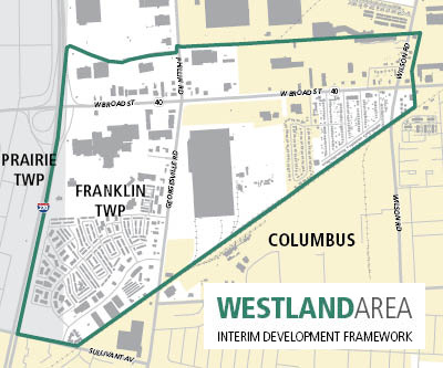
Planning area boundaries
Northern property line of parcels fronting West Broad Street (north)
Interstate 270 (west)
Camp Chase Railroad (south)
Eastern property line of parcels fronting Wilson Road (east)
The framework only applies to land in Franklin and Prairie Townships
The Framework: two components
The Westland Area Interim Development Framework is composed of two elements: The Development Principles and Future Land Use Map.
Development Principles: Goal-oriented statements describing desired characteristics of future development.
Future Land Use Map: Designations of the community's desired land uses for particular properties within the planning area boundary.
A first step
The framework will be used for an interim period. We anticipate a larger, comprehensive planning process that includes specific, targeted recommendations based on unique development considerations within the planning area.
Final approval
The Franklin County Board of Commissioners approved the Westland Area Interim Development Framework on June 8, 2010.
The commissioners' final action followed approvals by the Franklin and Prairie Township Boards of Trustees, the Franklin County Planning Commission and the Franklin County Rural Zoning Commission.
Westland Area Interim Development Principles
The framework is composed of two elements: The development principles and a future land use map.
Westland Area Interim Development Framework